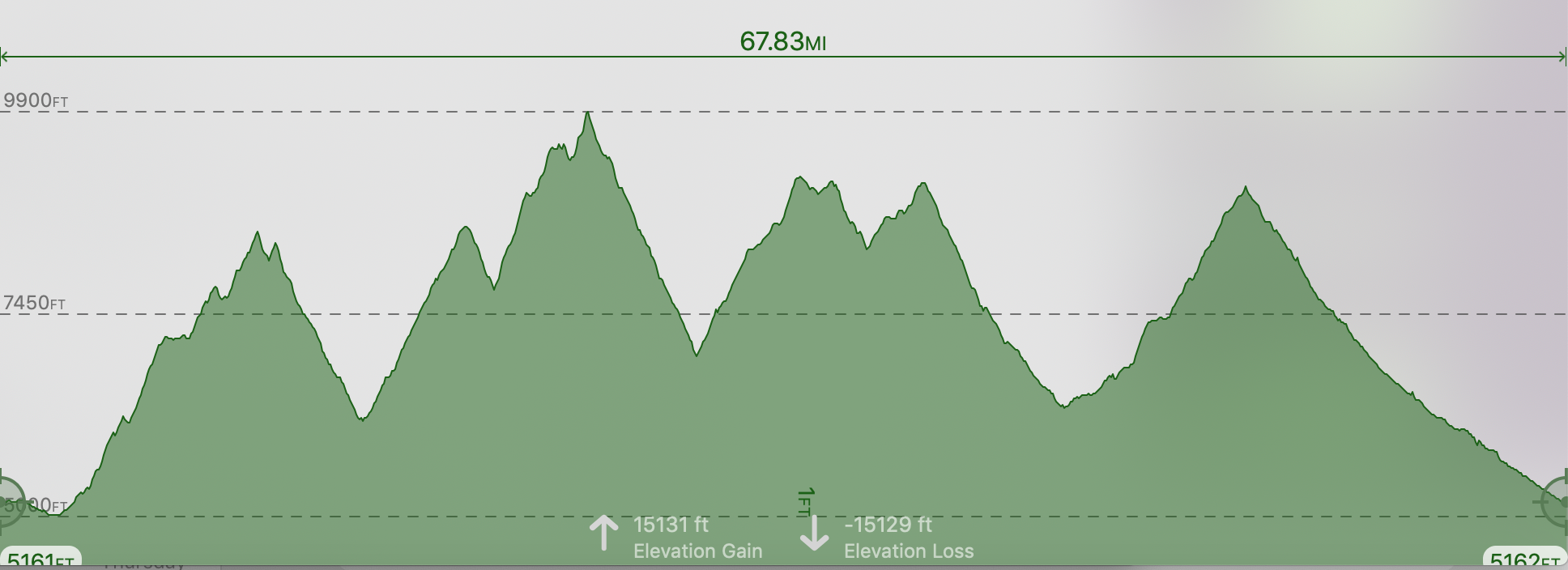
The 108K has about 17,000′ elevation gain and 9 aid stations. It is a large, single-loop course that has five significant climbs, two of which will take runners over 9000′ to nearly 10K. The majority of the course is on two-trail (meaning ATV width trail), with a few miles of dirt road, a lot of of single track trail, and some pavement at the finish coming into Challis.
The start is 5:00 am, with some intermediate cutoffs along the way.
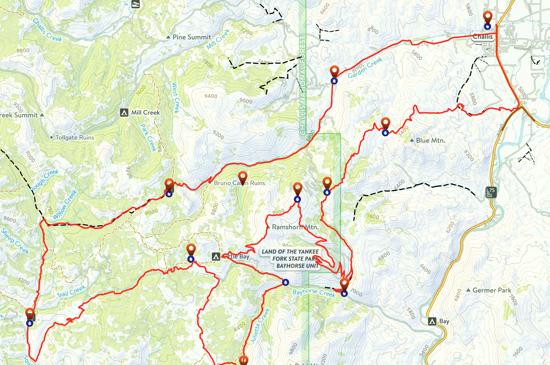
108K Overview Map
To view the gpx file, click on the red link and look in the left margin for your race.
108K Map File
108K Elevation Profile
108K Aid Stations:
Click on RED link:
RONR AID STATION CHARTS 2023

RONR 108K Course Description
START – BIRCH CREEK SADDLE (mile 9)
After leaving the START at the Challis City Park, you will head south on the HWY 93 shoulder for several hundred yards until reaching the 4-wheeler trail next to the highway on the right. Follow the two track trail to the Dump Road and jump on the trails winding through the sagebrush and over to the Lombard trail system, a two track trail that will lead you for quite some time. Stay on the Lombard Trail for a 4 mile climb, and up to a lower saddle where an informational placard will give you some geographic history of the surrounding area. Continue ~1.5 miles on the Lombard Trail (now cutting along Blue Mountain, side-hill) to the first Aid Station, BIRCH CREEK SADDLE.
BIRCH CREEK SADDLE – KEYSTONE (mile 12)
From BIRCH CREEK SADDLE, you’ll continue on the Lombard Trail and head up a tough climb before reaching another placard which describes the Bighorn Sheep in the area and their habitat. You wanted some views? Well here they are: The Salmon River below you, the Twin Peaks and the River of No Return Wilderness off to your right, Mt. Borah (Idaho’s tallest peak at 12,662’) off to the south skyline, and some wild, wild country ahead of you in the Salmon-Challis National Forest. The Lombard Trail climbs up to 8300’ now before descending sharply to an intersection where the aid station known as KEYSTONE will greet you. If you haven’t seen a deer, elk, antelope, sheep, bear, wolf, hawk or eagle by now then you hopefully registered under the Legally Blind category for the race.
KEYSTONE – BAYHORSE TOWNSITE (mile 16)
From the intersection at KEYSTONE, pick up Road 052 (go left-south) and ascend briefly to a summit before a 3.5 mile downhill cruise to the mining Ghost Town, BAYHORSE. You’ll pass by abandoned mines, outbuildings and rail car transport structures on your adventure to BAYHORSE. Watch for a fabled old miner in these parts, named Choppy. If you think you see him, run faster. As you approach BAYHORSE ghost town past the old hillside mill, your crew can watch for you on the hillside coming down to the aid station.
BAYHORSE TOWNSITE – RAMSHORN (mile 22.3)
From the Idaho State Park at BAYHORSE, you will backtrack up Road 052 for about a mile and take a left turn (West) on the Pacific Mine 4-wheeler road/trail. On the remaining 4000′ climb up to Ramshorn, the aid station called “Ramshorn” is a long way from the actual summit of Ramshorn mountain and will be a water drop only with some gels.
RAMSHORN– FRANCINE’S (mile 30.5)
The 4-wheeler trail now heads west, along the 9500’ ridge, probably with snow, before the ugly, nasty, I-hate-life 500 foot shale climb up to your high point on the course, Ramshorn. Depending on the topo map you reference, you will or won’t be over 10,000’–we’re telling you that you WILL. You now get to descend (yay!) Off to the left and down the old mining road past several abandoned mines as you work your way down back to Bayhorse Road. Once you reach the Bayhorse dirt road, you’ll go left, down the road for about 1.5 miles to the Juliette Creek Trailhead. NO CREWS ARE ALLOWED TO STOP AT FRANCINE’S AID STATION, even though it is on the Bayhorse Road.
FRANCINE’S – BAYHORSE LAKE (mile 38.5)
Tired of downhill? Good. Because now you get to head up the single track Juliette trail for 4 miles with many creek crossings before taking a sharp right onto a forgotten-about two-track and then up to the ridgeline, following a cairn-marked meadow to a jeep road on top of the ridge. This jeep road will now take you North for three miles before it ties back into the Bayhorse road, where you will turn left and head up and over to Bayhorse Lake.
BAYHORSE LAKE – SQUAW CREEK TH (mile 47.6)
YOU MAKE PICK UP A PACER BEGINNING AT BAYHORSE LAKE. Leaving BAYHORSE LAKE, a two track trail (TR 159) will lead you up 1.5 miles to a summit, over 9000’ again, before dropping into the Trealor Creek and Squaw Creek Drainages. After descending three miles on the two track (4-wheeler) trail, you will reach a dirt road at a place known as Cow Camp. Turn left and cross the cattle guard. The dirt road (RD 045) will lead you down another three miles in the Trealor Creek drainage to the main fork of Squaw Creek, where a right turn up the Squaw Creek Road (Rd 041) will take you one more mile to the aid station, SQUAW CREEK TH (TR149).
SQUAW CREEK TH – BRUNO CABIN (mile 57.6)
At the SQUAW CREEK TH, you will want to fuel up, hydrate, and gear up for a long, remote, but beautiful section that will lead you 3 miles into a huge mountain meadow. The two track (TR149) will turn to a single track after a couple miles, taking you to this mountain meadow (called The Willow Patch). After crossing a small creek in the meadow, you will now take a sharp right turn onto another single track trail that will take you up, yet again over 9000’, and drop down to Buster Lake and then on a dirt road for two miles to Bruno Cabin Aid Station.
*** Have warm clothes ready at Buster Lake! It is never warm up there once the sun dips!***
BRUNO CABIN – CUSTER MOTORWAY (mile 63.7)
After leaving BRUNO CABIN, the quad busting, 15 mile descent to the finish begins. 7 miles along Garden Creek on a 4WD road (RD069) will lead you back to your first signs of civilization in hours, and bring you to your final aid station, about ½ mile down from where the Custer Motorway ties into the Garden Creek Road (across from the Living Waters Ranch). You’ve now run 100K. If you are satisfied with that, you may stop. But no award and we will tattoo a large “D-N-F” on your backside.
CUSTER MOTORWAY – FINISH (mile 69.1)
We make no apologies for making you run another 5.4 miles. You signed up for it, and a simple 100K is for ninnies. AND… …you better have some speed left in your legs, because it is a perfect down hill grade, and it’s a paved country road! Departing the final aid station at the CUSTER MOTORWAY, you will take off on the final, well sloped downhill on a paved road which will lead you along Garden Creek. Now, down Main Street Challis, and back to the Challis City Park for the FINISH.